Semeru Part 7 - Track up to the top
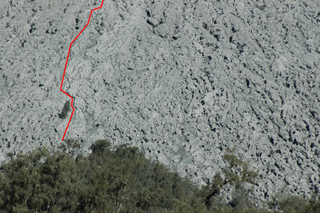
The zoom-up of the volcano shows the track to the top.

Maybe it is wrong to talk about a track. Till the treeline the mountaineer can follow a clear marked sometimes damaged track. The beginning of the "red line" is the end of the obvious track. Up there stones, ash and sand together with the volcanic activities make it difficult to establish a real path. Only some markings are showing the way up to the top. As well some "landmarks" are helpful like the small tree island beside the track.

Maybe it is wrong to talk about a track. Till the treeline the mountaineer can follow a clear marked sometimes damaged track. The beginning of the "red line" is the end of the obvious track. Up there stones, ash and sand together with the volcanic activities make it difficult to establish a real path. Only some markings are showing the way up to the top. As well some "landmarks" are helpful like the small tree island beside the track.
skaifyomonul - 3. Jul, 15:15


